ILE DE ST PAUL – PILOT
compiled by Lindsay May 22 October 2017
Tides:
Note 1.2m tide range 22 October 2017
Given this bay and narrow entrance I’d expect strong flow in and out – slack water should be mid tide not at high and low ends – just like Port Phillip Bay
Latitude/longitude: 38°43′00″S77°31′00″E
Decimal coordinates: -38.7167 77.5167
Altitude: 177 m.
Permanent GPS station at the Saint-Paul island tide gauge, Indian Ocean
Researchers from the LEGOS joint research unit (UMR5566, CNRS/Toulouse) in collaboration with the DT/INSU (UPS 855 CNRS/Brest) have installed a permanent GPS station at the Saint-Paul Island (38°41’S – 77°31 E) in the South Indian Ocean, on the GLOSS tide gauge site during the last NIVMER campaign. This installation was done in the framework of the French ROSAME sea level network. It aims at better constraining and explaining the recent estimation of relative sea level trend observed at this site, which is not significantly different from zero.
A data archaeology exercise was carried out on ancient sea level observations recorded during the transit of Venus across the Sun observed in 1874 from Saint-Paul Island, 38°41’S – 77°31 E, in the Southern Indian Ocean (Testut et al. 2010). Historical (1874) and recent (1994-2009) sea level observations were assembled into a consistent time series. A thorough check of the data and its precise geodetic connection to the same datum was only possible thanks to the recent installation of new technologies (GPS buoy and radar tide gauge sensor) and levelling campaigns. The estimated rate of relative sea level change, spanning the last 135 years at Saint-Paul, was not significantly different from zero (-0.1 ± 0.3 mm/yr), a value which could be reconciled with average global estimates of 1.7 mm/yr assuming the DORIS vertical velocity estimate at the nearby Amsterdam Island could be applied to correct for the land motion at the tide gauge (Altamimi and Collilieux, 2010). Considering the scarcity of long-term sea level data in the Southern Hemisphere, the exercise provides an invaluable additional observational constraint for further investigations of geographical sea level rise patterns.
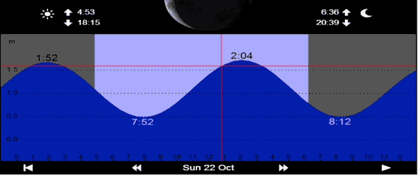
Figure 1. (right) MSL estimates at Saint-Paul relative to the hydrographic zero for the historic observations (1874) and the recent observations (2009). The error bars indicate the uncertainty of the estimates. The grey curve is the annual mean altimetric sea level at Saint-Paul Island from AVISO product and the associated MSL is shown over the period as a rough guide. The orange line shows the GIA-induced relative sea level change rate, and the blue lines indicate the lower, upper and best global sea level trend estimate over the 20th century.
The data from the permanent GPS station that has been installed will provide an invaluable estimate of the Island vertical land movement. This information is critical to better interpret the rather astonishing result of no relative sea level elevation during the past 135 years. It will also be usefull for geodynamic studies on the dormant volcano of Saint-Paul island or on plate tectonics.
Sea level at Saint Paul Island, southern Indian Ocean, from 1874 to the present
First published: 14 December 2010
Full publication history Abstract [1] A data archeology exercise was carried out on sea level observations recorded during the transit of Venus across the Sun observed in 1874 from Saint Paul Island (38°41′S, 77°31 E) in the southern Indian Ocean. Historical (1874) and recent (1994–2009) sea level observations were assembled into a consistent time series. A thorough check of the data and its precise geodetic connection to the same datum was only possible thanks to the recent installation of new technologies (GPS buoy and radar water level sensor) and leveling campaigns. The estimated rate of relative sea level change, spanning the last 135 years at Saint Paul Island, was not significantly different from zero (−0.1 ± 0.3 mm yr−1), a value which could be reconciled with estimates of global average sea level rise for the 20th century assuming the DORIS vertical velocity estimate at Amsterdam Island (100 km distant) could be applied to correct for the land motion at the tide gauge. Considering the scarcity of long-term sea level data in the Southern Hemisphere, the exercise provides an invaluable additional observational constraint for further investigations of the spatial variability of sea level change, once vertical land rates can be determined.
1. Introduction
[2] The study of global long-term sea level variability is a subject of major importance nowadays, due to its association with climate change and its direct societal impact. Enormous efforts have been undertaken to better understand the mechanisms that drive such variability, and previous works highlight the complexity of the response both over temporal and geographical scales [Holgate and Woodworth, 2004; Jevrejeva et al., 2006]. Even if satellite altimetry has proven to be a very powerful technology to derive a global overview of variability, such a picture can only be provided for the last two decades at most. Thus, one of the issues typically raised is the scarcity of sea level time series which span the past century and longer [e.g., Douglas, 2001; Woodworth, 2006]. On the other hand, the availability of such time series is mostly restricted to continental coastlines, and information about open ocean processes is limited, especially for the Southern Hemisphere. All these considerations make Saint Paul Island, due to its remote location in the southern Indian Ocean, a site of particular interest for sea level studies. [3] Saint Paul Island (Figure 1) is an ancient volcanic island located in the southern Indian Ocean (38°41′S, 77°31′E), part of the Terres Australes et Antarctiques Françaises (TAAF). It was discovered in the sixteenth century and annexed by France in 1843. The volcano collapse, some thousand years ago, brought about the inundation of its crater. Together with Amsterdam Island (approximately 100 km north of Saint Paul Island), it represents one of the few emergent points of a vast submarine volcanic plateau, situated along the Southeast Indian Ridge [Doucet et al., 2003]. Saint Paul and Amsterdam islands have a mild oceanic climate strongly influenced by the subtropical anticyclone and the westerlies, known as the roaring forties [Miller et al., 1993]. The presence of the Kerguelen plateau south of Saint Paul Island causes a significant component of the Antarctic Circumpolar Current (ACC) to be deflected to its northernmost position and to pass between Kerguelen and Saint Paul/Amsterdam islands [Park et al., 2009].![]()
Figure 1.
Map showing where the 9 December 1874 transit of Venus across the Sun was visible from the Earth. The red dots indicate the locations where the different nations sent their scientific expeditions to observe the transit. Saint Paul Island is located in the South Indian Ocean (Credits: IMCCE, Observatoire de Paris, P. Rocher).
As early as in 1874, Saint Paul Island was already the destination of a scientific expedition. Sea level measurements taken at that time enabled the calculation of a mean sea level (MSL) which was engraved on a rock. This mark has been recently discovered and leveled with respect to the local hydrographic zero defined for Saint Paul Island.
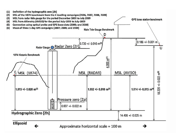 Figure 2.
Schematic view of the Saint Paul Island installation and main results of the leveling with respect to the hydrographic zero “Zh.” The uncertainties mentioned in this figure are the leveling errors (σL) indicated in Table 1. D, U, E denoted the location of the local benchmark network. Zr and Zp are the position of the instrumental reference of the radar and pressure gauge, respectively.
This paper will focus on the study of long-term sea level change based on a thorough analysis of the rescued 1874 data along with the most recent data obtained from a modern tide gauge installation. It will, therefore, represent one of the few data archeology exercises devoted to estimate the sea level change from historical information recorded in the Southern Hemisphere [Hunter et al., 2003; Woodworth et al., 2005, 2010; Testut et al., 2006;Watson et al., 2010]. In section 2, we will review the history of sea level observations at Saint Paul Island from the nineteenth century to the present. Section 3 will be devoted to the calculation of the MSL values and their uncertainty from the raw data. The estimation of the long-term sea level trend and the discussion of the results will be presented in section 4. Finally, section 5 contains the conclusions of the study.
Sea Level Observations at Saint Paul Island
1. Historic Measurements
In the early 1870s, the astronomers of many nations gathered to prepare observation task forces for an important astronomic phenomenon, the transit of Venus across the Sun, due to take place on 9 December 1874, in the middle of the Austral summer. This phenomenon was of major importance as it would permit an accurate determination of the Astronomical Unit, that is, the distance between the Sun and the Earth, which is used to estimate the distances between the planets in the solar system.
[2] The islands that make up the actual TAAF represent the majority of the land in the Indian Ocean between 45°and 50°south and they were of particular interest for the observations of the Transit. The French Academy of Sciences organized expeditions to China, Japan, New Caledonia, New Zealand (Campbell Island) and Saint Paul Island (Figure 1). The Saint Paul Island expedition was led by Ernest Mouchez who set up instruments on the island in September 1874. The expedition stayed at Saint Paul Island until the beginning of 1875. During that period, a tide staff was installed and sea level readings were continuously recorded every half an hour from 6 October 1874 to 31 December 1874. The mean value of these measurements (uncorrected for the inverse barometer effect) was calculated on-site and then transferred to a mark struck in a nearby rock (Figure 2), providing a valuable reference point with which to estimate the evolution of MSL at the island. Other variables such as atmospheric pressure, humidity and air temperature were also recorded. A summary of those observations was published by the French Academy of Sciences [Mouchez, 1878] together with a thorough description of the meteorological conditions [Rochefort, 1878]. The mark was rediscovered in 1994 during an archeological inventory, but it was attributed to the mean sea level data mentioned by Mouchez [1878] only in late 2006 after an historical investigation (completed by the authors). The mark was subsequently leveled during the maintenance visits undertaken in 2006, 2007, 2008 and 2009 (the mission reports are available online athttp://www.legos.obs- mip.fr/en/observations/rosame/communication/rapports/). [3] From the Mouchez [1878] report, we digitized the high and low water heights that were corrected by him for the inverse barometric effect, as well as the daily mean barometric pressure reduced at MSL spanning the same whole period (6 October 1874 to 31 December 1874). The original raw half-hourly sea level and barometric pressure values from the expedition have not been traced as yet. However, a copy of tabulated hourly values (for October and November) was found at the SHOM archive (Service Hydrographique et Océanographique de la Marine) and used by Gougenheim [1949] to compute the tidal constituents at Saint Paul Island. All the above mentioned measurements and related historical documents have been used to assess the quality of the sea level observations, and to estimate the uncertainty associated with the 1874 MSL determination.2. Modern Measurements
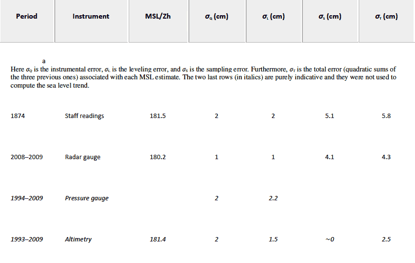
[4] The Saint Paul Island station is part of the ROSAME (Réseau Sub-antarctique et Antarctique du niveau de la MEr) tide gauge network, one of the French contributions to the Global Sea Level Observing System (GLOSS) program of the Intergovernmental Oceanographic Commission (IOC) of UNESCO [Woodworth, 1997]. The first modern tide gauge station at Saint Paul Island was established in 1994, and equipped with a subsurface pressure tide gauge installed in a stilling well. Measurements began on 25 October 1994 and continued to the present with only a few short gaps due to reasons such as battery failure or satellite transmission problems. Most of the available sea level data were acquired with Aanderaa WLR7 subsurface pressure tide gauges. Those gauges measure changes in the total bottom pressure (including sea level and atmosphere) and are equipped with a temperature sensor and occasionally a conductivity sensor. There is also an atmospheric pressure sensor installed in a nearby hut. The sea level measurement is derived from the difference between bottom and atmospheric pressure taking into account the value of local gravity and the density. Density is derived from in situ ocean temperature and salinity when available. But for most part of the record the salinity was assumed to be constant. The assumption leads to submillimeter uncertainty in the sea level calculation. From November 2008 onward, the station was also equipped with a radar tide gauge (Khrone Optiflex) installed in the same stilling well as the pressure tide gauge. Unfortunately, only 7 months of data have been recovered because of an electronic failure of the station, resulting in a loss of data since July 2009. Due to its remote location, maintenance visits at Saint Paul Island are generally undertaken only once a year during the logistical rotation of the French research vessel Marion Dufresne. This imposes serious handicaps on the ability to react to a problem, once detected, irrespective of the measurement system. In addition to this, being part of a national protected area, access to the island is strictly limited and those visits must be extremely short, typically a few hours. [10] Over the period 1994–2005, maintenance visits basically consisted in replacing the batteries and sensors. From 2006 onward, other operations have been added. These have been related to the importance of controlling the tide gauge datum for monitoring of a possible vertical movement of the instrument. Consequently, regular leveling campaigns have been undertaken. Finally, in November 2008, a GPS equipped buoy was deployed during two days in the vicinity of the tide gauge station in order to calibrate and define the datum of the radar sensor. GPS equipped buoys have proven useful to achieve in situ calibrations of tide gauges located in remote islands [e.g., Watson et al., 2008]. Further calibration was also performed in 2008 and 2009 by means of visual observations using an optical probe, confirming the results obtained with the GPS buoy and showing the stability of the radar sensor zero reference. A summary of the leveling and MSL values is shown in Figure 3. The MSL for the recent period used in this paper was derived from the radar measurements over the 7 months period from December 2008 to July 2009 (Table 1).Table 1. Summary of the MSL and Associated Errors for the Different Periods and Instruments
3. Uncertainty Estimates
[11] As already mentioned, an important focus of this paper is to carefully evaluate the sources of uncertainty affecting the estimation of the MSL at both extremes of our timeline. This estimate is affected by three categories of errors. A first one, σQ, can be related to the intrinsic quality of the data used to produce the MSL estimate. The second one is related to the connection of the MSL to a common datum (Zh) during the measuring period (defined as the leveling error, σL). Finally, it is essential to consider to what extent the estimated averages over a short period are representative of the value over an extended period (one or two decades), as the short-period measurements can be affected by seasonal and interannual variability (defined as the sampling error, σS). [12] In sections 3.1 and 3.2 we will assess all those errors both for the historical and the modern measurements. In some cases the errors will be corrected for or considered negligible. In others, they will simply contribute to the overall uncertainty estimation. The results of this assessment are summarized in Table 1.Île Saint-Paul
From Wikipedia, the free encyclopedia Not to be confused with Saint Paul Island, Alaska, St. Paul Island, Nova Scotia, or the former name for Nuns’ Island, or St Paul’s Island, Malta.
Geography: Coordinates 38°43′48″S 77°31′20″E
Area: 6 km2 (2.3 sq mi)
Length: 5 km (3.1 mi)
Highest elevation : 268 m (879 ft)
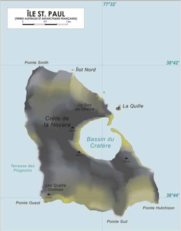
Highest point: Crête de la Novara
Administration: France
Île Saint-Paul (Saint Paul Island) is an island forming part of the French Southern and Antarctic Lands (Terres australes et antarctiques françaises, TAAF) in the Indian Ocean, with an area of
6 km2 (2.3 sq mi). The island is located about 85 km (53 mi) southwest of the larger Île Amsterdam, and 3,000 km (1,900 mi) southeast of Réunion. It is an important breeding site for seabirds. A scientific research cabin on the island is used for scientific or ecological short campaigns, but there is no permanent population. It is under the authority of a senior administrator on Réunion.
Description
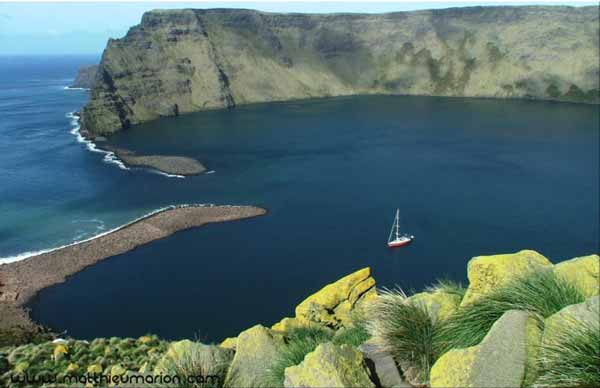
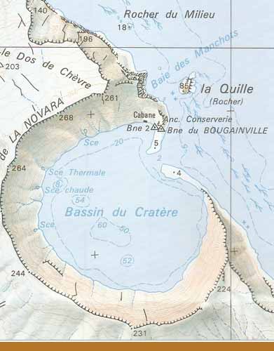
Île Saint-Paul is triangular in shape, and measures no more than 5 km (3.1 mi) at its widest. It is the top of an active volcano, the volcano last erupted in 1793 (from its SW Flank), and is rocky with steep cliffs on the east side. The thin stretch of rock that used to close off the crater collapsed in 1780, admitting the sea through a 100 m (330 ft) channel; the entrance is only a few meters deep, thus allowing only very small ships or boats to enter the crater. The interior basin, 1 km (0.62 mi) wide and 50 m (160 ft) deep, is surrounded by steep walls up to 270 m (890 ft) high. There are active thermal springs.
History
Early sightings
Île Saint-Paul was first discovered in 1559 by the Portuguese. The island was mapped, described in detail and painted by members of the crew of the Nau São Paulo, among them the Father Manuel Álvares and the chemist Henrique Dias. Álvares and Dias correctly calculated the latitude as 38°South. The ship was commanded by Rui Melo da Câmara and was part of the Portuguese India Armada commanded by Jorge de Sousa. The Nau São Paulo, who also carried women and had sailed from Europe and had scale in Brazil, would be the protagonist of a dramatic and moving story of survivalafter sinking south of Sumatra.
The next confirmed sighting was made by Dutchman Harwick Claesz de Hillegom on 19 April 1618.[1] There were further sightings of the island through the 17th century. One of the first detailed descriptions of it, and possibly the first landing, was made in December 1696 by Willem de Vlamingh.[1][2]
19th century
During sailing ship days captains would occasionally use the island as a check on their navigation before heading north. Saint-Paul was occasionally visited by explorers, fishermen, and seal hunters in the 18th and 19th centuries, among which was the American sealer General Gates, which called at the island in April 1819. George William Robinson, an American sealer, was left on the island to hunt seals, and stayed there for 23 months until the General Gates returned for him in March 1821. Robinson subsequently returned to Saint-Paul in 1826 to gather sealskin, sailing from Hobart aboard his own vessel, the schooner Hunter.
France’s claim to the island dates from 1843, when a group of fishermen from Réunion, interested in setting up a fishery on Saint-Paul, pushed the Governor of Réunion to take possession of both Saint-Paul and Amsterdam Island. This was performed by means of an official decree dated 8 June 1843, and on 1 July, Martin Dupeyrat, commanding the ship L’Olympe, landed on Amsterdam Island and then on Saint-Paul on 3 July, and hoisted the tricolor. The only surviving evidence of this claim is an inscribed rock situated on the edge of Saint-Paul’s crater lake, inscribed “Pellefournier Emile Mazarin de Noyarez, Grenoble, Canton de Sassenage, Département de l’Isère, 1844”. All fishery operations were, however, abandoned in 1853, when the French government renounced its possession of the two islands.[3]
The first good map of the island was not drawn up until 1857, when the Austrian frigate Novara landed a team which studied the flora, fauna, and geology from November to December.[4] In 1871, a British troop transport, HMS Megaera, was wrecked on the island. Most of the 400 persons on board had to remain upwards of three months before being taken off. A short, impressionistic account of the two French residents encountered by the shipwrecked crew appears in Judith Schalansky’s Atlas of Remote Islands (2010).[5]
In September 1874, a French astronomical mission conveyed by the sailing ship La Dive spent just over three months on Saint-Paul to observe the transit of Venus; geologist Charles Vélain took the opportunity to make a significant geological survey of the island.
In 1889, Charles Lightoller, who was later to become famous as the Second Officer of the RMS Titanic, was shipwrecked here for eight days when the sailing barqueHolt Hill ran aground. He describes the shipwreck and the island in his autobiography, Titanic and Other Ships. Lightoller speculated that pirates may have used the island and their treasure could be buried in its caves.[6]
In 1892, the crew of the French sloop Bourdonnais, followed by the ship L’Eure in 1893, took possession of Saint-Paul and Amsterdam Island in the name of the French government.
20th century
In 1928, the Compagnie Générale des Íles Kerguelen recruited René Bossière and several Bretons and Madagascans to establish a spiny lobster cannery on Saint-Paul, “La Langouste Française”. In March 1930, at the end of the second season, most of the employees left, but seven of them stayed on the island to guard the installations, supposedly for just a few months. But the promised relief arrived much too late. When the ship finally came, in December 1930, five people had died, mostly from lack of food and scurvy: Paule Brunou (a child born on the island who died two months after her birth), Emmanuel Puloc’h, François Ramamonzi, Victor Brunou, and Pierre Quillivic. Only three survivors were rescued. This event has since come to be known as Les Oubliés de Saint–Paul (“the forgotten ones of St. Paul”).[7][8]
A few years later in 1938, the crew of a French fishing boat were stranded on the island. Distress calls sent by the crew over short-wave radio were fortuitously received 11,000 miles away in the United States. The message was relayed to the Navy and the French consul in San Francisco, while 12-year-old Neil Taylor, an amateur radio operator in California, made contact with the stranded crew and assured them that help was on the way.[9]
Environment
See also: Amsterdam and Saint-Paul Islands temperate grasslands
The island has a cool oceanic climate and the slopes of the volcano are covered in grass. It is a breeding site for subantarctic fur seals, southern elephant seals androckhopper penguins. It was also the breeding site for an endemic flightless duck & several kinds of petrel before the introduction of exotic predators and herbivores, including black rats, house mice, European rabbits, pigs and goats during the 19th century or earlier. The pigs and goats have since disappeared or been eradicated. Black rats were eradicated in January 1997 following an aerial drop of 13.5 tonnes of brodifacoum anticoagulant poison baits over the island.[10]
Important Bird Area
The island, with the adjacent islet of Quille Rock, has been identified as an Important Bird Area (IBA) by BirdLife International because it supports several breedingseabirds. The island’s subtropical location gives it an avifauna distinct from that of subantarctic islands and contains several breeding species which are rare in the region. Saint Paul’s seabirds nested mainly on Quille Rock until rat eradication allowed some species, notably Macgillivray’s prions (a subspecies of Salvin’s prion) and great-winged petrels, to recolonise the main island.[10]
Other species include a colony of some 9000 pairs of northern rockhopper penguins, about 20 pairs ofsooty albatrosses, a few pairs of Indian yellow-nosed albatrosses, and small numbers of Australasian gannets, fairy prions, little and flesh-footed shearwaters,Wilson’s storm petrels and sooty terns.[11] important breeding ground for a number of seabirds including an endemic subspecies of Medium-billed Prion (Pachyptila salvini macgillivrayi). n 1928, the Compagnie Générale des Íles Kerguelen recruited René Bossière and several Bretons and Madagascans to establish a spiny lobster cannery on Saint-Paul, “La Langouste Française”. When the company went bankrupt in 1931, seven of its employees were stranded on the island. Five died, the two survivors were finally rescued in 1934. This event has since come to be known as Les Oubliés de Saint-Paul (“the forgotten ones of St. Paul”) and the French maintain a cabin for scientists to live in while doing research there, Stone ruins mark two abortive attempts to settle on Saint Paul in the past. At lower right are the remnants of a rock lobster cannery that operated from about 1910 to 1930. Notice the barrel- shaped plugs of cement that lie in a heap on the shore; they were brought by a ship that had the misfortune of them getting wet in passage.
An ill-fated lobster cannery was started on the island and then abandoned, unfortunately its employees were stuck on the island and all but two of them starved before they could be rescued. The ruins of the old stone cottages are still there.
You can see evidence of this human activity as well as the rock with the original French inscription laying claim to the island on the shores of the lagoon.
Ile Saint Paul: Claimed by France since 1893, the island was a fishing industry center from 1843 to 1914. In 1928, a spiny lobster cannery was established, but when the company went bankrupt in 1931, seven workers were abandoned. Only two survived until 1934 when rescue finally arrived.
Description
Location and General Description
Amsterdam and Saint-Paul are subantarctic volcanic islands in the southern Indian Ocean, located approximately 80 km from each other (Jouventin 1994). Among the most remote islands in the world, Amsterdam and Saint-Paul are more than 3,000 km from any continent, situated between Antarctica, Africa, and Australia. Amsterdam (37°50’S, 77°31’E) is an island of about 55 km2, with an extinct volcano reaching 911 m altitude. The island is relatively recent, having formed between 400,000 and 200,000 years ago (Jouventin 1994). Numerous craters and vents are present, though there has been no recent volcanic activity. The western part of the volcano collapsed, forming vertical cliffs of 400-700 m. Saint-Paul is a much smaller island, only 7 km2, and reaching an altitude of 272 m. Saint-Paul’s volcanic crater is striking; it is flooded and open to the sea on one side, creating an enclosed harbor with cliffs rising vertically from the water. Together with the Crozel and Kerguelen archipelagoes and the Antarctic territory of Terre Adèlie, Saint-Paul and Amsterdam are part of the French Southern and Antarctic Territories, formed in 1955.
altitude. The island is relatively recent, having formed between 400,000 and 200,000 years ago (Jouventin 1994). Numerous craters and vents are present, though there has been no recent volcanic activity. The western part of the volcano collapsed, forming vertical cliffs of 400-700 m. Saint-Paul is a much smaller island, only 7 km2, and reaching an altitude of 272 m. Saint-Paul’s volcanic crater is striking; it is flooded and open to the sea on one side, creating an enclosed harbor with cliffs rising vertically from the water. Together with the Crozel and Kerguelen archipelagoes and the Antarctic territory of Terre Adèlie, Saint-Paul and Amsterdam are part of the French Southern and Antarctic Territories, formed in 1955.
Approximately 500 km north of the Antarctic convergence, Amsterdam and Saint-Paul have a moderate oceanic climate. Surface seawater temperature varies from 12.7° in August to 17.4° in February. Air temperatures vary from 11.2° in August to 17° in February, with an annual average of 13.5° (Carroll 2001). Relative humidity is generally high due to the frequency of low cloud ceilings, and ranges from 80% in March to 82.9% in November. Rainfall is high with an annual average of 1,114 mm distributed over 239 days and falling primarily as rain. Hail or snow is observed in winter but seldom at low altitudes. December through March is drier (78 mm per month) than April to November (100 mm per month) (Carroll 2001).
The flora of Amsterdam Island is patterned in clearly marked vegetation types according to altitude (Georges 1999). The lowland area originally supported a native Phylica forest mixed with ferns such as Elaphoglosum succaesifolium, Gleichenia polipodioides, and Ploystichum adiantiforme (Jouventin 1994). Also present were flowering plants (Plantago stauntoni, Acaena sanguisorbae) and liverworts (Marchantia spp.), and glades were characterized by rushes (Scirpus nodosus and Juncus australe) (Jouventin 1994). This was broken by the high coastal cliffs to the Southwest, where two grasses (Poa novarae and Spartina arundinacea) and a rush (Scirpus nodosus) were dominant. Highland slopes were characterized by an association of clubmoss (Lycopodium trichiatum), a fern (Gleichemia polypodioides), and flowering plants (Poa fuegiana, Acaena seurguisarbae, Scirpus aucklandicus, Uncinia brevicaulis, and Trisetum insulare) (Jouventin 1994). Ranunculus biternatus and Callitriche antarctica grew in the few areas with running water. The peat-bog of the central plateau, “Plateau des Tourbieres”, persists much as it was before human interference; it is chracterized by mosses growing in association with Lycopodium saurusus, Scirpus aucklandicus, Trisetum insulare, and Uncinia compacta (Jouventin 1994).
The vegetation of Saint-Paul island is similar to that of Amsterdam, though with less altitudinal variation and without the presence of the Phylica tree. Grass and tussock grass occur on dry, lower slopes, sedges grow in wetter areas, and the rocky shores of the island are generally covered by introduced, invasive species (UNEP 1998).
Biodiversity Features
Amsterdam and Saint-Paul Islands are typical of many isolated island ecosystems, in that there is a paucity of species in conjunction with a high rate of endemism. The original high endemism of Amsterdam and Saint-Paul Islands’ avifauna was likely a result of its unique biogeographical position. Not only are the islands very isolated, they also have the added factor of being located near subantarctic islands, but in subtropical waters.
Species likely emigrated from the colder islands, and then underwent speciation adapting to the markedly different environment of warmer waters. The Tristan da Cunha-Gough Islands lie at the same latitude in the Atlantic Ocean, though oceanic currents result in their waters being colder and not much different than nearby subantarctic islands. Thus, this island group had a lower original endemism rate of seabirds as adaptations were less necessary there than at Amsterdam and Saint-Paul Islands (Jouventin 1994).
Amsterdam Island is the only French subantartic isle that supports a native tree, Phylica nitida. In the Rhamnaceae family, this tree has small, narrow leaves and honey-scented yellow flowers, reaches 6-7 m, and is abundant on the Tristan da Cunha-Gough Island group, a separate ecoregion, in the Atlantic Ocean (Jouventin 1994). An early description of Amsterdam Island from 1726 described an almost impenetrable Phylica forest in a belt around the island at 100 to 250 m covering almost a third of its surface. At present the “Grand Bois” (large forest) is the only thick remnant of Phylica on the eastern coast covering about 8 hectares, or about 0.2% of the whole island (Jouventin 1994). This dramatic reduction was likely the result of cutting, fires and destruction by the cattle that were introduced in the later 1800s and are now wild. The “Grand Bois” has been fenced and bordered by introduced cypresses as protection from the cattle. A few isolated Phylica trees subsist outside of this area either in protected zones or in areas inaccessible to the cattle (Georges 1999). A fern, Hymenophyllum aeruginosum, is a threatened plant native to Amsterdam Island (UNEP 1998).
The original native fauna of Amsterdam and Saint-Paul Islands was quite unique before the arrival of humans. Fossil records show that Amsterdam Island avifauna until recently comprised a likely 22 species (Jouventin 1994). There are currently only 10 or 11 breeding seabird species, of which 4 are extremely rare. The endemic Amsterdam albatross (Diomedea amsterdamensis) is one of the worlds rarest species of avifauna, found only on Amsterdam Island; this remnant population is restricted to the upland Plateau des Tourbières and has only 10 pairs breeding in any single year (Jouventin 1994; Inchausti and Weimerskirch 2001). Individuals breed every other year, and the entire population of Diomedea amsterdamensis is estimated at only 70 individuals (Jouventin 1994). Thus, this species is considered to be under serious threat of extinction. Macgillivray’s race of Salvin’s prion (Pachyptila salvini macgillivrayi) is an subspecies endemic to the ecoregion with less than 200 breeding pairs. Once very abundant on Amsterdam and Saint-Paul, Pachyptila salvini macgillivrayi, with its distinct wide blue beak, has significantly decreased in number on Amsterdam Island. The species has also retreated to breed on Roche Quille (150-200 pairs), a small rock offshore of Saint-Paul that is safe from predators (Jouventin 1994). One of the most abundant species on the islands is the yellow-nose albatross (Diomedia chlororhynchos). This ecoregion supports approximately 80% of the world’s population, or about 37,000 breeding pairs (Jouventin 1994; UNEP 1998). Other residents of the islands are sooty albatross (Phoebetria fusca) (240 pairs), remnant populations of soft-plumaged petrel (Pterodroma mollis) and grey petrel (Procellaria cinera), antarctic tern (Sterna vittata tristanensis), brown skua (Catharacta lonnbergi), and common waxbill (Estrilda astrild) (introduced 1977-1985) (Jouventin 1994). Of the species that disappeared, four were probably endemic; these were a flightless duck and a storm-petrel, both undescribed, and likely two petrels of the genera Pterodroma and Procellaria (Jouventin 1994).
Another resident of this island group is the rockhopper penguin (Eudyptes chrysocome moseleyi). Rockhoppers in the northernmost breeding region of Amsterdam, Saint-Paul and Tristan-Gough Islands form the distinct moseleyi subspecies, which have longer crests than their colder climate relatives. Quite an unusual looking creature, these penguins have orange-red bills and bright red eyes in addition to their elaborate yellow and black crests.
Seals have long used Amsterdam and Saint-Paul Islands, and were once so numerous that reports stated that their multitudes made landing impossible. The subantarctic fur seal (Arctocephalus tropicalis) continues to breed on the islands, and had an estimated 20,000 adults in 1981 (UNEP 1998). While the southern elephant seal (Mirounga leonina) no longer breeds on the islands, its numbers have been increasing (UNEP 1998). Elephant seals exhibit the greatest sexual dimorphism among all mammals in regard to weight, with males weighing up to five tons whereas females only rarely weigh over one ton (Georges 1999). Both seals were approaching extinction on Amsterdam Island at the beginning of the 20th century but have been recovering since protections were put in place and are now re-established all over the island (Carroll 2001).
Five cattle were introduced to Amsterdam Island in 1871, then increased to about 2,000 individuals in 1987. The herd has been completely naturalized, surviving without humans for over a century. The cattle feed on rushes and withstand the dry season when no surface water is available (Jouventin 1994). Their unusual existence has presented a unique challenge in conservation management, as the cattle are both the main threat to endangered indigenous species as well as one of the very few feral herds of Bos taurus anywhere in the world (Micol and Jouventin 1995). A compromise was made to divide the island with a fence in 1987, with cattle enclosed in the smaller southern section. It is hoped that this will allow the ecosystem to be rehabilitated while preserving the scientific interest of the herd.
Current Status
Amsterdam Island is the most degraded of the French southern island territory, having suffered drastically during the eighteenth century due to its position in the direct route of ships sailing between South Africa and Australia. Many ships stopped here to collect wood. Between 1792 and 1974, several peat fires occurred on the island (at least four known to have been started accidentally by humans) and further reduced the island’s native Phylica forest (Jouventin 1994). Erosion naturally followed destruction of the forest, eliminating significant habitat for the burrowing petrel species (Jouventin 1994). Invasive plants have also changed the landscape significantly. Lowland meadow now covers most of the area that was once thick with native Phylica forest.
Certain plant species were introduced for grazing domestic animals, such as velvetsoft meadow grass (Holcus lanatus) and dandelion (Leontodon taraxacoides), and have flourished due to their ability to withstand the trampling of cattle (Georges 1999). A recent introduction, thistle (Cirsium vulgare), has spread extensively since a 1974 fire (Georges 1999). The residual area of Phylica trees stretches along the island’s eastern slope between the “Grand Bois” (large forest) and the “Chaudron” (the cauldron).
The greatest impact to the island’s fauna occurred during the intensive sealing exploitation which decimated the subantarctic fur seal populations. It is thought that 150,000 fur seals from Amsterdam and Saint-Paul Islands were killed between 1789 and 1835, and their complete disappearance followed in 1893 (Jouventin 1994).
Around 1880, fur was no longer in great demand, and eventually the subantarctic fur seal population returned and experienced a rapid regrowth that now appears to have stabilized (Guinet et al. 1994). Human visitors also killed penguin, albatross and petrels for food or fishing bait. Introductions of various animals occurred both accidentally and deliberately. Some such as dogs (Canis familiaris) and pigs (Sus scrofa) disappeared, though pigs likely first caused significant damage by destroying bird burrows and eating eggs. Goats (Capra aegagrus) survived on the island for 100 years, causing severe damage to vegetation, and were eventually eradicated intentionally. Mice (Mus musculus), rats (Rattus norvegicus), and cats (Felis catus) remain and are skilled predators of the native birds. The remaining populations of burrowing petrels, soft-plumaged petrel (Pterodroma mollis) and grey petrel (Procellaria cinera), are hunted by rats and cats; in addition to eating eggs, cats are able to catch adults at the entrance of burrows. However, it is thought that these species recently have had less impact on the reduced bird populations than have the feral cattle, which indirectly harm native birds through destruction of their habitat.
Amsterdam Island was included in the Parc National Antarctique Francais in 1938, and currently houses a small population of 30 or so researchers and military personnel at its scientific and meterological base, which was established in 1949. It was the discovery in 1983 of the relic population of Amsterdam albatross (Diomedea amsterdamensis) that resulted in the establishment of a restoration program (Micol and Jouventin 1995). Several measures have been taken to regain a portion of the biodiversity lost from this ecoregion. It is known that the Amsterdam albatross once bred across a much larger area, and it is hypothesized that indirect competition with the feral cattle population reduced their breeding area, along with other seabirds (Jouventin 1994). Among other benefits, a division of the island and regeneration of the native forest may help the threatened albatross to gain in numbers. The restoration program has begun replanting Phylica trees in the northern section of the island, which is protected from the cattle. A management plan is also in place to control the size of the herd, which has provided meat to the people at the base for some time.